Itinerary
End to End - Malvern Hills
Linear walk around the Malvern Hills
Itinerary details
Information about this itinerary
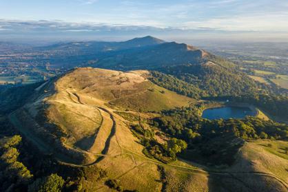
This trail follows the top of the Malvern Ridge from Chase End at the south to North Hill taking in the main summits.
As this is a linear walk we strongly recommend that you arrange to be dropped off at the start point at Chase End. If you do park here please be considerate of local residents and other road users when parking. If the small parking area (N.B. it only accommodates c. 6 vehicles) at Chase End is full, please consider using the Malvern Hills Trust car park at Hollybush.
Rather than undertake the walk all in one day, it can be readily divided into sections, using, for example, the car parks and facilities at British Camp and the Wyche as start or end locations to walk sections.
Walk Start Location
Approximate Postcode: HR8 1SE
Grid Reference: SO 75726 34940
What3Words: ///opera.reputable.deck
Key information
- Duration :
- 5 Hours
- Categories :
Walking
In this itinerary
See what this itinerary includes
Malvern Hills AONB
The Malvern Hills are a 15km range of ancient rocks made up of a complex assemblage of crystalline igneous and metamorphic rocks (granite) of pre-Cambrian age…
Location, location, location
See where this itinerary takes place
Share
This Itinerary