
Itinerary
Worcestershire Beacon - Circular Walk
A circular walk starting at Beacon Road car park
Itinerary details
Information about this itinerary
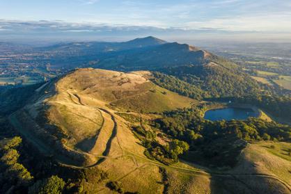
Passing initially around the western slopes of Worcestershire Beacon, with magnificent views (weather permitting) over Herefordshire and beyond to the Black Mountains. The trail then climbs the delightful valley of The Dingle reaching its highest point with views to the east and west. Swinging round and down Happy Valley to St Ann’s Well, continuing along the eastern slopes with views over Great Malvern and the Worcestershire Plain. Visiting the hidden Earnslaw pool, before a short climb up through woodland to the Goldmine stone way marker and the return to Beacon Road.
Refreshments are available most days at Cafe H2O (GeoCentre) and midway at St Ann’s Well.
Walk Start Location
Approximate Postcode: WR14 4EH
Grid Reference: SO 76861 43928
What3Words: ///shortcuts.panicking.diggers
Key information
- Duration :
- 1.5 Hours
- Categories :
Walking
In this itinerary
See what this itinerary includes
Malvern Hills AONB
The Malvern Hills are a 15km range of ancient rocks made up of a complex assemblage of crystalline igneous and metamorphic rocks (granite) of pre-Cambrian age…
Location, location, location
See where this itinerary takes place
Share
This Itinerary